| 1 |
 |
“...LIST OF MAPS AND PLANS
Maps The West Indies . . . . after PAGE xiv
Bermuda . . . . • , .* 42
New Providence, the Bahamas * • it 60
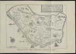
"A TOPOGRAPHICALL DESCRIPTION AND AD- MEASUREMENT OF THE YLAND OF BARBADOS ” „ 72
Reproduced from Ligon’s Map, dated 1657 Barbados ....... 76
Trinidad and Tobago . • • , 116
Grenada, St. Vincent and the dines . Grena- 154
St. Lucia, Antigua, St. Kitts, Nevis,
Dominica and Montserrat . 168
Jamaica .... 254
Guadeloupe, Martinique, Marie Galante AND THE SAINTES . . . . 300
The Virgin Islands 320
Cuba and Porto Rico . 340
Haiti and Santo Domingo 362
British Guiana 370
Dutch Guiana or Surinam 412
The Panama Canal . . facing 422
xi...”
|
|
| 2 |
 |
“...MORE GENERAL INFORMATION
3i
The route usually followed from northern ports to
Jamaica is past Watling’s Island and through the
Crooked Island and Windward Passages (see map).
Steamers for the Lesser Antilles keep well out in the
Atlantic. If the steamer arrives at Jamaica, as she
generally does, at dawn, it well repays one to be on deck
very early to see the sun rise over the glorious Blue
Mountains, putting to shame the blinking light of the
lighthouse at Plum Point.
The difference of a voyage under modem conditions
from one made in the old days has often been emphasised,
and tourists who are lucky enough to be able to obtain
copies of “ Monk ” Lewis’s “ Journal ” or Jeaffreson’s
" A Young Squire of the Seventeenth Century ” may sit
in comfort in their deck chairs as the steamer forges
her way along at a speed of from fifteen to nineteen
knots and read of the discomforts with which their for-
bears had to put up.
Christopher Jeaffreson, having bid his friends...”
|
|
| 3 |
 |
“...BERMUDA
5i
that vessel and the American frigate Chesapeake off
Boston on June 1st, 1813. It hangs in a niche in the wall
near by. After a desperate encounter lasting eleven
minutes, during which Captain Philip Vere Brooke of the
Shannon was disabled, and Captain Lawrence of the
Chesapeake was fatally wounded, the American vessel
after a gallant fight was compelled to strike her colours,
which now hang in the Royal United Service Museum
in Whitehall, London. The bell, which bears the date
1740, was cracked by a bullet.
Below the niche is a tablet inscribed :
Bell said to have belonged to H.M.S. Shannon
AND DAMAGED DURING HER ENGAGEMENT
with the U.S. Frigate Chesapeake
ist June, 1813.
This historic bell was exhibited in the Bermuda Pavilion
at the British Empire Exhibition at Wembley in 1924
and 1925.
The road for carriages or cyclists to Ireland Island is
clearly shown on the map which faces page 42. Pedes-
trians can take a short cut by crossing by ferry from...”
|
|
| 4 |
 |
“...I Atopographicall Description anti
j\.dme asurement of the YLAND of
BARBADOS m theWeft INBVAESj
Witk-lkeHL Hairier öf tke ScueraH piantacons-cr I
5 ^
A
«.<* .«a
S\ MÏ
TF”
k^dfL />/>
«S($y
• ■iUBi r>^0 „
a 40 % n«D
- 4cy>»!
<&
\l
JA <&
^ I
MW
a
<2 •>
tfwgglf
'%£& &
>w#;
-O'- v
Crv>riy
„ V—
\obb- ''^/ZjuZ
lütsjfë**
A-.Seo.le tf Juit Ttiles
Richard Ligon’s Map of Barbados published in
1657...”
|
|
| 5 |
 |
“... admitted, has rooms
devoted to bridge and dancing, and extensive grounds, where
lawn tennis is played. The Public Library occupies a handsome
building in Woodford Square. It has a large and well-stocked
free reading-room, and a library containing 25,000 volumes
which is open daily (Sundays excepted) from 8 a.m. till 9 p m‘
Subscription, 12s. ($2.88) or £1 ($4.80) per annum, for two or
four volumes, payable yearly, quarterly, or monthly A
Soldiers’ and Sailors’ Club is on the east side of the Savannah.
SIGHTS. Vessels bound for Port of Spain enter the
Gulf of Paria by one of the Bocas del Dragón (the
Dragon’s mouths), the straits formed by the islands of
Chacachacare (the name is an Indian one), Huevos (egg)
and Monos (monkey), and known respectively as the
Bocas Grande, Navios, Huevos, and Monos (see map,
after page 116). Chacachacare, .on which a tall light-
house is conspicuous, is a leper settlement. On the other
islands there are pleasant villas which are much resorted...”
|
|
| 6 |
 |
“...136 POCKET GUIDE TO THE WEST INDIES
town the road strikes north again, and, running in a
north-easterly direction., passes through Matura Village
and districts devoted to the cultivation of coco-nuts, to
Salybia and Balandra Bays near the northern end of the
East Coast or Bande de 1’Est. Here there are glorious
expanses of white sand from which delightful surf-
bathing can be enjoyed in the open Atlantic. The east
coast (see map, after p. 116) has three great bays, namely
those of Matura, Cocos, and Mayaro, each of which should
be visited if time permits. For the greater part of its
length the entire coast is fringed with coco-nut palms,
and it is said that the Cocal, as the coco-nut grove
between Manzanilla and Radix Points is called, owes its
origin to a French vessel laden with coco-nuts having
been wrecked there and to some of the nuts having been
washed ashore and having taken root. The north-east
trade-wind, fresh from across 3,900 miles of ocean, blows...”
|
|
| 7 |
 |
“... Virgin
to St. Mary’s Village, eight miles away to the north, for
greater safety, and that next day she found her way ;
back to her shrine as the Bambino of the Ara Cceli did in
Rome.
An opportunity of seeing something of the varied
scenery of the coasts of Trinidad is afforded by Govern-
ment steamer, which also maintains communication with
Tobago. On one route the steamer goes through one of
the Dragon’s mouths, and passing the exquisitely
beautiful bays of Macqueripe, Maracas and Las Cuevas
calls off Blanchisseuse, Matelot, Grand Rivière and Toco
(see map, after page 116), crossing thence to Tobago.
On the other route she leaves by the Serpent’s Mouth
and proceeds along the south coast, affording views of
the three mountains which reminded Columbus of the
Trinity and so gave the island its name, and then round
Cape Galeota up the east coast, calling off Mayaro before
crossing to Scarborough.
Off Erin a remarkable manifestation of submarine
volcanic activity was...”
|
|
| 8 |
 |
“... opened in 1864) and the Government
Buildings are situated on the wharf, adjacent to the
landing-place. At the Library an interesting old map...”
|
|
| 9 |
 |
“... opened in 1864) and the Government
Buildings are situated on the wharf, adjacent to the
landing-place. At the Library an interesting old map...”
|
|
| 10 |
 |
“... of Sir Charles
Metcalfe (1839-1841), for the white troops in the days
when yellow fever was rife in the plains. The barracks,
mess-rooms,etc., are perched in tertaces on the mountain-
side and command superb views of Kingston and its
harbour lying like a relief-map far below. Away to the
west on a slightly higher elevation are the cantonments
of Greenwich.
Since the disbandment of the West India Regiment
in 1926, the white troops have been stationed at Up Park
Camp to the north of Kingston.
From Newcastle to Catherine’s Peak there is a fair
riding road. The view of both sides of the island from
the summit (5,036 feet) is very beautiful. The road from
Newcastle is continued to Hardwar Gap and down the
Buff River Valley to Buff Bay on the north side of the
island. This main road reaches a higher point (just
over 4,000 feet) than any other in the island, and the
scenic drive—^Kingston, Newcastle, Hardwar Gap, Buff
Bay, Annotto Bay, Castleton Gardens, Stoney Hill...”
|
|
| 11 |
 |
“... priced owing to
the low Customs duties.
The streets are clean and well cared for, and it used
to be said that, during the Danish régime, visitors found
by the police to have" dined not wisely but too well,
were compelled to expiate their overnight offence by
sweeping the streets in the morning.
Good pedestrians can obtain a superb view by ascend-
ing the mountain by the rough path behind “ 1829 ” to
Mafolie. From this spot an extensive panorama unfolds
itself. Far below are the town and harbour spread
out like a map. Under the shelter of Cowell’s battery
are the wharves formerly owned by the Hamburg-
American line. Away to the west he the islands of
Culebra and Vieques, and to the east St. John, Tortola,
and several small islets of the Virgin group. To the
south lies St. Croix. Out to sea is the historic Sail Bock
which, during the American War, received severe
punishment from the captain of a French frigate who
mistook it for an enemy ship. He hailed it through his...”
|
|
| 12 |
 |
“...r®ÈOLW;
o/vffö'istobal
KlVlr. iiix'5*
LfM
• V map
PaNAMAT CANAL
s “To Miles
**/LWAYS'
ea&Co.Lid. St James'St London....”
|
|