|
|
|
Your search within this document for 'sindrom,down' resulted in 32 matching pages.
|
| 1 |
 |
“...6 GUIDE TO THE WEST INDIES
prevalence of the trade-winds for the greater
part of the year, the heat of the sun is far less
felt than it is at the same temperature in New
York or London, and for this reason sunstroke
is practically unknown in the West Indies; but,
all the same, visitors should on no account
expose themselves to the direct rays of the
noonday sun. A thorough wetting by the rain
should be guarded against, and chills at sun-
down avoided. Of late years, the sanitary ar-
rangements in the West Indies have undergone
substantial improvement, with the result that out-
breaks of yellow fever are of extremely rare_ occur-
rence, and they seldom, if ever, occur in the
winter months. Malaria of a mild form is met
within most of the islands in the summer months
—Barbados being a notable exception—but new-
comers are not as a rule susceptible to it until
they have resided for at least ten or twelve months
in the West Indies, and tourists therefore need
feel no...”
|
|
| 2 |
 |
“...GENERAL INFORMATION
3i
are aboard, and the steamer is slipping down
Southampton Water, passing Netley on the left,
or the port side, as it should now be called. On
turning into the Solent, Cowes is seen, and then
in succession Yarmouth, Totlands Bay, Alum Bay,
and the Needles to the left, with Hurst Castle
standing out on a spit of sand to the right.
The pilot is dropped off the Needles, and the
steamer proceeds to Cherbourg, where passengers
are embarked that evening, and thence, under the
present arrangements, to Vigo, whose magnificent Vigo,
bay has been the scene of many naval engage-
ments. The town was assaulted and burnt by the
English under Drake and Norris in 1589; and,
on October 22, 1702, the combined English and
Dutch fleets attacked the French and Spanish
in the port. Several men-of-war and galleons
were taken and many destroyed, and an abund-
ance of plate and other valuable effects fell into
the hands of the conquerors. Vigo was taken
by Lord...”
|
|
| 3 |
 |
“... three times:— p
i i
“ And the sun went down, and the stars came out tar
over the summer sea,
But never a moment ceased the fight of the one and t
the fifty-three. I
Ship after ship, the whole night long, their high-built s
galleons came, c
Ship after ship, the whole night long, with her battle
thunder and flame.”
Here it was that Sir Richard, shot through the body
and through the head, having been carried by the
stately Spanish men to their flagship, said...”
|
|
| 4 |
 |
“...Barbados.
Jamaica.
34 GUIDE TO THE WEST INDIES
and this is soon expended. The fish forces its
way through the water, and, rising from it, is
carried forward and skims the surface, gaining
momentum each time it touches the waves.
The size of the fish is that of a small herring;
and there are always many old travellers who
will tell one how they have seen the fish fly on
board the ship, though really this can only occur
on sailing ships whose gunwale is near the water,
unless, perhaps, the fish flies through the port-
hole.
The first sight of Barbados is, as a rule, ob-
tained overnight, when the Ragged Point light is
seen blinking on the starboard bow, and Carlisle
Bay is generally reached in the early morning,
when the sun rises over a scene of considerable
animation. The novelty of the surroundings will
never be forgotten. A string of lighters emerges
from the harbour and bears down upon the
steamer to tranship baggage. Boatmen jostle
each other about the...”
|
|
| 5 |
 |
“...GENERAL INFORMATION
35
be on deck very early to see the sun rise over the
glorious Blue Mountains of Jamaica, putting to
shame the blinking light of the lighthouse at
Plum Point.
The difference of a voyage under such conditions An old-time
from one in the old days has often been empha-Voyage'
sised, and tourists who are lucky enough to be
able to obtain copies of Monk Lewis’ “ Journal ”
or Jeaffreson’s “ Young Squire of the Seventeenth
Century ” may sit in comfort in their deck chairs
as the steamer forces her way along at a speed
of from fifteen to nineteen knots and read of
the discomforts with which their forebears had to
put up. Jeaffreson took leave of his friends at
Billingsgate, was rowed down to Gravesend on
16th February 1675-6, and went aboard the
“Jacob and Mary, a vessell of about a hundred
and fifty tunns, 14 or 16 gunns, and a square
stearne.” This was on Thursday, and on Sunday
she anchored in the Downs, “where we went
ashoar; but the wind in two...”
|
|
| 6 |
 |
“...S2 GUIDE TO THE WEST INDIES
Chronological History of the West Indies. 3
vols. By Capt. Thomas Southey. London,
1827.
The West Indies and Spanish Main. By
Anthony Trollope. London: Chapman & Hall,
i860. 5s.
y The English in the West Indies. By J. A.
A 1^ Froude. London: Longmans, Green & Co., 1888.
6d.
Tom Cringle’s Log. By Michael Scott.
Peter Simple. By Captain Marryat.
A Historical Geography of the British Colonies.
Vol. II. The West Indies. By C. P. Lucas.
Oxford: Clarendon Press, 1890 (2nd edition, re-
vised by C. Atchley, I.S.O., 1905).
Down the Islands. By W. A. Paton. London :
Kegan Paul, Trench & Co., 1888.
In Sugar Cane Land. By Eden Phillpotts.
London : McClure & Co., 1893. 3s. 6d.
The West Indies and the Empire. By H. de
R. Walker. London: T. Fisher Unwin, 1901.
7s. 6d.
The Report of the West India Royal Commis-
sion, 1897, with Appendix by Sir Daniel Morris,
K.C.M.G. (C. 8655). 2S. 6d.
The Colonial Office List. London: Waterlow
and Son, Ltd...”
|
|
| 7 |
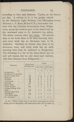 |
“...
Carrington . 81 1 0 0 6
Sunbury 9Ï 1 3 0 7
Bushy Park . II 1 6 0 8
Three Houses I2f i 9 0 8
College Siding Halt
Bath .... 15Ï 2 0 0 10
Martin's Bay Halt Bathsheba . 19I 2 6 1 0
Joe's River Halt .
St. Andrew’s 24 2 6 1 0
At the “ Halts,” trains stop to set down passengers on notice
being given to the guard, and passengers may also be taken up
£...”
|
|
| 8 |
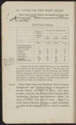 |
“...86 GUIDE TO THE WEST INDIES
First class return tickets are issued at single fare
and one-third,
to Monday.
pecial arrangements for Saturday
West Coast Railway
Distance from George- town. Fares from Georgetown.
1st Single. 1st Return. 2nd Single.
Miles. Cents. Cents. Cents.
Vreed-en-Hoop . ...
Windsor Forest*
Den Amstel* 32 42 16
Hague 3* 42 16
Leonora 4 42 56 20
Uitvlugt* .
Boeraserie . 12 56 74 28
TusgJjgn 13J 60 80
Greenwich Park. is 72 96 36
* Trains stop at these stations by signal, or on informing
the conductor at the preceding station. The fare from the
preceding station is charged. On the Demerara and Berbice
Railway passengers may be taken up or set down at any of the
customary side lines, namely, Success, La Bonne Intention,
Mon Repos, Lusignan, and Hope, on payment of an extra fare
of 48 cents for each stop outside the station.
Ferries. Ferry-boats cross the Demerara River between
Georgetown and Vreed-en-Hoop at frequent in...”
|
|
| 9 |
 |
“... to Rockstone on the Esseauebo. and thence
• So i«in«k a to 6 days "being required for the
For those with less time at their
ijd
If*
by launch, 4
expedition.
Rockstone. disposal, the trip from Rockstone to the Etaballi
Etabaiii Falls is recommended. A lively boat’s crew of
Bucks or aboriginal Indians and “ Boveanders,” as
the cross between the Negro and Buck is called,
paddle one down 8 miles to the Etaballi Falls,
the passage of which is very exciting. The
captain stands on the poop steering with a
paddle tied to the gunwale and exhorting his
Falls....”
|
|
| 10 |
 |
“... were ledges, on which grew
a few green plants. Some idea of the size of
these cliffs may be drawn from the fact that the
field-glasses showed these plants to be tall forest
trees. . . . After two hours’ climb through the
forest, we came out on the savannah from which
the Kaieteur falls. . . .
“Crossing the savannah we soon reached the
Kaieteur cliffs. Lying at full length on the
ground, head over the edge of the cliff, I gazed
down. Then, and only then, the splendid and, in
the most solemn sense of the word, awful beauty...”
|
|
| 11 |
 |
“...w
BRITISH GUIANA 97
of the Kaieteur burst upon me. Seven hundred
and fifty feet below, encircled in black boulders, lay
a great pool, into which the columns of white water,
graceful as a ceaseless flight of innumerable rockets,
thundered from by my side. Behind the Fall,
through the thinnest parts of the veil of foam and
mist, a great black cavern made the white of the
water look yet more white.”
Sir E. im Thurn visited the Fall again in 1879.
This second visit was made at the end of a heavy
rainy season, when the scene presented a much
grander aspect. He thus describes it:—
“Crossing the savannah, and coming to the
edge of the cliff over which the Potaro falls, we
once more lay down, bodies along the top of the
cliff, heads over its edge. It was a very different
scene from the last time. Then it was beautiful
and terrible; but now it was something which it is
useless to try to describe. Then a narrow river,
not a third of its present width, fell over a cliff in...”
|
|
| 12 |
 |
“...JAMAICA 121
such as orange, cocoa, rubber, nutmeg, clove,
mango, sarsaparilla, cinnamon, coffee, &c. Castle- Castleton
ton Gardens in the parish of St Mary, on the Gardens-
road between Kingston and Annotto Bay, contain
a large collection of tropical plants and economic
spice and fruit trees. The Gardens are a 19
mile drive over Stoney Hill and down the valley
of the Wag Water. The expedition requires a
whole day, and lunch may be had at Castleton
Cottages. Port Royal stands at the extremity of Port Royal,
the spit of sand known as the Palisadoes, which
protects Kingston Harbour. It is of great historic
interest, and was, prior to the earthquake of 7th
June 1692, considered “the finest town in the
West Indies, and at that time the richest spot
in the universe,” being as it was the head-
quarters of the buccaneers, and as such the
emporium and mart of their ill-gotten wealth.
The rector of the parish thus described the
disaster“ Whole streets, with their inhabitants...”
|
|
| 13 |
 |
“...JAMAICA 123
military camp, and on to Hardware Gap, is a drive
well worth taking for the magnificent panorama
obtainable. The road continues down the Buff
Bay River valley to Buff Bay on the north side of
the island. Spanish Town, or St. Jago de la Vega, Spamsh
on the banks of the Rio Cobre (Jhourfrom Kingston own'
by train), was the former capital of the island. It
was once a town of considerable importance, and
the well-constructed group of Government Build-
ings round its central square testifies to its former
grandeur. Among the more notable of these are
the old King’s House, the official residence of
former Governors, on the west side. It was built
from designs by Craskell, the then engineer of the
island. The plans were approved during the
administration of Lieutenant-Governor Henry
Moore in 1759-1762, and the building was com-
pleted in 1762, after the arrival of the Governor,
William Henry Lyttelton. The expense of build-
ing the House, which was considered...”
|
|
| 14 |
 |
“... of
* B‘ Spain and the neighbourhood. The town is well
built, and certainly one of the finest in the West
Indies. The streets, which are well proportioned,
are lighted by electricity, and have an excellent
service of electric cars running through them (see
page 137). The telephone system is very com-
plete. Brunswick Square, in the middle of which
is a fountain presented by the late Mr. Gregor
Turnbull, is a centre of interest. On the west
Red House, side of it is the Red House, or Government Build-
ing. It was burnt down during a riot on March
23, 1903, but it has since been rebuilt on a greatly
Port of
Spain.
Brunswick
Square.
L...”
|
|
| 15 |
 |
“...CHAPTER VII
TOBAGO
Robinson Crusoe's Island
General If for no other reason than that it was the
pect' island from which Defoe drew his descriptions for
his immortal work, “ Robinson Crusoe,” Tobago
has a peculiar fascination and charm. It lies
about 75 miles south-east of Grenada and only
about 20 miles north-east of Trinidad, the actual
distance between Scarborough, its chief town,
and Port of Spain being 70 miles, and the
nearest points in the two islands Point Petit
and Point Galera respectively. The island, of
which the population is a little over 20,000, is
26 miles long and 7! miles wide at its greatest
breadth, and has a total area of 114^ square
miles. Unlike its neighbours, it lies east and
west. The island is of volcanic formation, and
a main ridge of hills 18 miles in length runs
down the centre of the northern portion, cul-
minating in Pigeon Point, which is 1900 to 2000
feet above the sea. Long deep valleys run up
to it from either side, divided from...”
|
|
| 16 |
 |
“...CHAPTER VIII
GRENADA
“ Clarior e tenebris"
Grenada, the most southerly island and the seat General
of government of the British colony known as the Aflpeot'
Windward Islands, lies 90 miles to the north of
Trinidad, 68 miles south-south-west of St. Vincent,
and 150 miles south-west of Barbados. It is
about 21 miles long and 12 miles broad, its total
area being 123 square miles, or about half the
size of Middlesex, and its population 68,253.
The island is very mountainous, and is only *
equalled by Dominica for the beauty of its tropi- |
cal scenery. The highest point is Mount St.
Catherine, 2749 feet, from which spurs branch
off, forming^valleys of great beauty and fertility.
Along the east and south-east coast the mountains
gradually slope off to the sea, but on the whole of
the west coast the mountains run sheer down.
The island is purely volcanic in its origin, the
chief centres of eruption appearing to have been
in the neighbourhood of Mount St. Catherine and...”
|
|
| 17 |
 |
“...ST. VINCENT
179
with its houses along the shore painted in the
same tints of blue or yellow or pink as those in
Norway, with the same red-tiled roofs, the trees
coming down the hill sides to the water’s edge,
villas of modest pretensions shining through the
foliage, with the patches of cane fields, the
equivalent in the landscape of the brilliant Nor-
wegian grass. The Government Offices, the Post Government
Office, and the Colonial Bank are within a stone’s Office
throw of each other near the centre of the town, Colonial
and Government House, the residence of the Government
Administrator, is at the back of the town above House-
the Botanic Garden, on the left-hand side looking
from the harbour.
The market is amusing during the busy hours Market,
early in the morning. A comprehensive view of
a large part of the island, with its picturesque
mountains and valleys covered with rich tropical
vegetation, can be obtained from the Mount St. Mount
Andrew (2600 feet), the...”
|
|
| 18 |
 |
“...ST. VINCENT
i85
by the weirdness of the scene we had witnessed,
and covered with the still thickly falling grey
dust. . . . The awful scene was again renewed
yesterday (Thursday, the 8th) and again to-day.
At about 8 a.m. the volcano shot out an imijiense
volume of material which was carried in a cloud
over Georgetown and its neighbourhood, causing
not only great alarm, but compelling the people
by families to seek shelter in other districts.”
The usual plan adopted by visitors who wish
to see the crater is to leave Kingstown by the
mail canoe which starts each day at 2 p.m. for
Chateaubelair, calling at the small leeward towns
of Layou and Barrouaille en route, and arriving
at 6 p.m., after giving the passengers an admirable
view of the forest-clad hills of the island and the
narrow valleys which run down to the sea. Pre-
vious to starting, however, the permission of the
chief of police should be obtained for the use
of the Government Rest Room at the police...”
|
|
| 19 |
 |
“...186 GUIDE TO THE WEST INDIES
seen, and also the former site of Richmond village,
which was completely effaced and where many
lives were lost. On reaching the lower lip of the
crater, one has a fine view of the devastated area
and also of other parts of the island, besides the
large crater lake. The return journey from
Chateaubelair can be made by mail canoe, which
leaves each morning at 6 p.m. and reaches Kings-
town at io a.m. The cost of this excursion should
not exceed jQi. For those who do not care for a
long day in an open boat at sea, the Soufrière can
be approached by road. All round the southern
end of the island, down the Palm Avenue, across
Arno’s Vale, and through the little town of
Calliaqua, winds the great road to Georgetown
on the eastern or windward coast, by which the
prosperous planters of the fertile Carib country
used to communicate with Kingstown. With an
early start, a riding horse, or carriage with a pair
of ponies, can easily cover the...”
|
|
| 20 |
 |
“...r
CHAPTER X
ST. LUCIA
“ Statio hand malefida carinis ”
General St. Lucia, which lies about 20 miles to the south
poot- of Martinique, and 30 miles to the north-east
of St. Vincent, has a total area of 233 square
miles, being rather smaller than Flintshire, and
a population of 50,000. Its greatest length is
42 miles and its greatest breadth 21 miles. St.
Lucia is volcanic, and consequently very moun-
tainous. The scenery throughout the island is
truly magnificent. The main range of mountains,
of an average height of 1500 feet, runs north and
south nearly the whole length of the island,
buttressed by numerous ridges branching off from
it gradually sloping down to the sea on either
side, leaving narrow fertile valleys between them.
The flattest parts of the island are at Gros Islet,
at the extreme north-west, and Vieuxfort, at the
south-east, where the backbone ceases, giving
place to a plain. The Canaries Mountain (3140
feet), near the centre of the island, is the...”
|
|
|