| 1 |
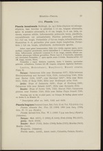 |
“...Masjiboeri, Moesti sdmbo.
Plate II.
Curasao: Calcareous hills near Hermanus 5077; Hills between
Hieronymusberg and Savonet 5124, 5128; Antonyberg 5146; Hills
near Barber 5180, 5182*; near Davelaar 5401*; Hills near Blein
5515; Hofje of Knip 5539; Hills near Brakkeput ariba 5548.
Aruba: Slope of Jamanota 6299; Slope of Hooiberg 6365;
Calcareous hills near Belashi 6430*; Hills near Savaneta 6532.
Bonaire: Slope of Joewa 7200, 7222; Rincon 7022; Calcareous
plateau near Fontein 7248; Hills near Salina Playa Grandi 7293.
Occuring only in the wooded parts; on Curasao 20 finding places noted
on Aruba 6, on Bonaire 12.
* Description after no. 5401, 5182 and 6430.
Pisonia fragrans Dumont Cours. Bot. Cult. II ed. Yol. YII (1814) 114;
Pisonia obtusata Sw. Flor. Ill (1806) 1960 (non Jacq. 1798);
Gris. FI. 71 p.p. (Symb.);
Pisonia inermis Gris. Flor. W. I. (1859) 7 (p.p. non Jacq.) (Symb.).
(Johnston).
Curasao : Mah (4857); C (5002); K (5464); Hwk (5564); Wh (5577).
Aruba: Savh (6533).
Bonaire : Macb (7123);...”
|
|
| 2 |
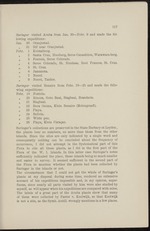 |
“...Oranjestad.
Febr. 1 Kristalberg.
II 2 Santa Cruz, Hooiberg, Seroe Canashitoe, Warawara berg.
II 3 Fontein, Seroe Colorado.
n 4 Seroe Colorado, St. Nicolaas, Rooi Frances, St. Cruz.
it 5 St. Cruz.
» 6 Jamanota.
1) 7 Noord.
u 9 Noord, Tankie.
Suringar visited Bonaire from Febr. 19—25 and made the folio-
wing expeditions: <■
Febr. 19 Fontein:
II 20 Rincon, Goto Baai, Slagbaai, Brandaris.
II 21 Slagbaai.
II 22 Boca Onima, Klein Bonaire (Molengraaf!).
- 'II 23 Playa.
II 24 Bolivia.
II 25 Witte pan.
II 26 Playa, Klein Curasao.
Suringar’s collections are preserved in the State Herbary et Leyden,
the plants bear no numbers, no more than those from the other
islands. Since the sites are only indicated by a single word and
consequently nothing can be concluded about the frequency of
occurrence, I did not attempt in the Systematical part of this
Flora to cite all these plants, as I did in the first part of the
Flora of the W. I. Islands. In this latter case Suringar’s notes
sufficiently...”
|
|
| 3 |
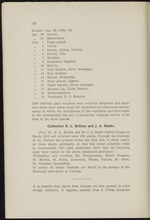 |
“...120
Bonaire: Jan. 28—Febr. 20.
Jan. 30 Rincon.
71 31 Makoetakau.
Febr. 1 Playa grandi.
n 2 Joewa.
71 4 Rincon, Onima, Fontein.
n 5 Rincon, Tola.
n 7 Karakau.
7) 9 Brandaris, Slagbaai.
71 10 Bolivia.
7) 11 Rooi Samboe, Seroe montagna.
71 12 Rooi Samboe.
11 14 Rincon, Kralen dijk.
71 15 Seroe grandi, Lagoen.
71 16 Tanki maraka, Seroe montagna.
11 17 Bacuna, Lac, Klein Bonaire.
71 18 Zuidzoutpannen.
71 19 Vuurtoren N. 0. Bonaire.
2200 different plant numbers were collected altogether and elabo-
rate notes were taken about the occurrence of conspicuous species,
owing to which the descriptions of the vegetation and other notes
in the Systematical list give a' practically complete survey of the
flora of the three islands.
Collection N. L. Britton and J. A. Shafer.
Prof. Br. N. L. Britton and Dr. J. A. Shafer visited Curasao in
March. 1913 and collected some 250 plants. Through the kindness
of Dr. Britton the present writer has been able to study nearly
all these plants personally, so that this...”
|
|
| 4 |
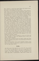 |
“...127
Mont Plaisant to beyond the estate Siberie and reaches its hig-
hest point in Seroe Kloof and Seroe Dakoe.
From here to St. Kruisbaai and Playa Grandi a hilly country ex-
tends, which only in a new places (Dokterstuin) reaches 130 M.
Near Anthonieberg (160 M.) a hilly country of greater height be-
gins, forming the centre of the region North of St. Kruisbaai and
Anthonieberg; we find there the complexes Tafelberg, 230 M.,
the top of which consists of chalk, and Christoffelberg, with
ramifications extending to Wbstpuntbaai and St. Kruisbaai.
Anthonieberg, Tafelberg and Christoffelberg are, excepting a few
coast mountains, the only heights in West CuraQao which may
be properly called mountains; they are the only ones which stand
more or less alone. Christoffelberg is 372 M. high and has slopes
that cannot be ascended; a road, consisting of sharp prominent
rocks, winds from Savonet to the top. All other heights on West
CuraQao, on the other hand, are only separated by slightly inclined...”
|
|
| 5 |
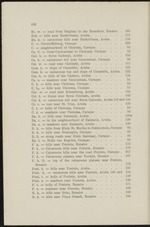 |
“...top of the calcareous plateau near Fontein,
Bonaire .......................................... • 173
Font. h. = hills near Fontein, Aruba . . . . . . . 137
Font. k. = calcareous hills near Fontein, Aruba 140 and 154
Font. t. = hofje of Fontein, Aruba.....................u - 139
Font. z. = seashore near Fontein, Aruba. ..... 138
F. t. = hofje of Fontein, Bonaire..........................171
F. z. = seashore near Fontein, Bonaire . 169
G. h. = hills near Goto, Bonaire . 183
G. h. = hills near Playa Grandi, Bonaire . ... . 164...”
|
|
| 6 |
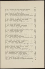 |
“...193
Gr. k. = calcareous soil near Playa Grandi, Bonaire . . 162
Gr. k. z. = seashore near Playa Grandi, Bonaire. . . . 163
H. = slope of the Hieronymusberg, Curagao................345
He. h. == hills near Hermanus, Curagao........................96
He. k. = calcareous hills near Hermanus, Curagao ... 97
H. h. = hills between Hieronymusberg and Savonet, Curagao 346
H. k. — calcareous hills near Hato, Curagao . . . . . 365
H. k. = calcareous top of the Hieronymusberg, Cüragao . 344
H. Mi ’== road from San Maria to Hato, Curagao. . . . 366
Ho. h.'= slope of Hooiberg, Aruba. . . . v . . . 120
Ho. w. — road from St. Cruz to Hooiberg, Aruba . . . 119
H. S. = hills between Hieronymusberg and Savonet, Curagao 347
H. t. = hofje of Hato,-Curagao .........................368
H. w. = hills to the seaside of Knip, Curagao .... 78
Hw. k. = calcareous soil near Knip, Curagao...................80
Hw. z. =:; seashore near Knip, Curagao...................... 79
H. z. = from Anthonyberg to the northern...”
|
|
| 7 |
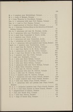 |
“...Curagao . . . .
Pi. k. = calcareous hills near Seroe Salinja, Curagao .
Pi. t. — Hofje Klein Piscadera, Curagao . ... . . .
P. h. == hills near St. Patrick, Curagao...............
P. k. = calcareous hills near St. Patrick, Curagao . .
P. k. h. '=* hills near St. Patrick, Curagao . . . .
P. k. z. = seashore near St. Patrick, Curagao . .
Pla. k. = calcareous soil near Playa Grandi, Bonaire .
PI. d. = sandy seashore near Playa Grandi, Bonaire .
PI. h. = hills near Salina Playa Grandi, Bonaire . .
PI. k. = calcareous hills and plateau near Playa Grand
Bonaire . . ... . . .....................
PI. k. z. = calcareous seashore near Playa Grandi, Bonaire
P. R. w. = road from Fontein to Seroe Grandi, Bonaire
R. = neighbourhood of Rincon, Bonaire . . . . .
R. = road near Ronde Klip, Curagao . . ■ .
R. h. = hills near Rincon, Bonaire......................
R. h. = slope of Ronde Klip, Curagao . . . . • -
325
318
65
304
303
76
77
145
66
107
108
99
100
168
150a
72a
72Ö
861
360
362
30
29
316
369
28
315
69...”
|
|
