 |
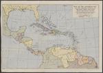
| Map of the Caribbean, etc., and other territories covered by the "The West Indies Year Book", showing their relative positions |
|
| Publisher: | | Geographia Ltd. ( London ) |
| Publication Date: | | [20th century] |
| Type: | | Map |
| Format: | | 1 map : colour print ; 35 x 49 cm. |
| Source Institution: | | Universiteit Leiden |
| Subject Keyword: | | Midden-Amerika |
| Spatial Coverage: | | Midden-Amerika |
| Language: | | English |
|
| Map of the Caribbean, etc., and other territories covered by the "The West Indies Year Book", showing their relative positions |
|
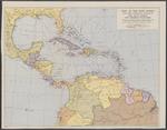 |
| Map of the West Indies and other territories covered by "The West Indies Year Book" |
|
| Publisher: | | Geographia Ltd. ( London ) |
| Publication Date: | | [20th century] |
| Type: | | Map |
| Format: | | 1 map : colour print ; 38 x 49 cm. |
| Source Institution: | | Universiteit Leiden |
| Subject Keyword: | | Midden-Amerika |
| Spatial Coverage: | | Midden-Amerika |
| Language: | | English |
|
| Map of the West Indies and other territories covered by "The West Indies Year Book" |
|
|
|
