 |
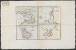
| Port, baye cul de sac Royal dans la Martinique |
|
| Creator: | | Buache, Philippe, 1700-1773 |
| Publication Date: | | [1740] |
| Type: | | Map |
| Format: | | 4 maps in 1 sheet : copper engraving, color ; sheet 35x53 cm. |
| Source Institution: | | Universiteit Leiden |
| Subject Keyword: | |
Bahama's
Caribisch gebied
Kaarten (geografie)
|
| Spatial Coverage: | |
Bahama's
Caribisch gebied
|
| Genre: | | Kaarten (geografie) (gtt) |
| Language: | | French |
|
| Port, baye cul de sac Royal dans la Martinique |
|
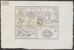 |
| Port de St. Augustin |
|
| Creator: | | Buache, Philippe, 1700-1773 |
| Publication Date: | | [1740] |
| Type: | | Map |
| Format: | | 7 maps in 1 sheet : copper engraving, color ; sheet 35x53 cm. |
| Source Institution: | | Universiteit Leiden |
| Subject Keyword: | |
Bahama's
Caribisch gebied
Kaarten (geografie)
|
| Spatial Coverage: | |
Bahama's
Caribisch gebied
|
| Genre: | | Kaarten (geografie) (gtt) |
| Language: | | French |
|
| Port de St. Augustin |
|
|
|
