|
|
| |
|
|
|
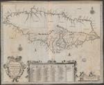 |
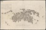
| Novissima et accuratissima Jamaicae Descriptio |
|
| Creator: | | Ogilby, John, 1600-1676 |
| Publication Date: | | 1671 |
| Type: | | Map |
| Format: | | 1 map : engraving ; 43,5×54 cm. |
| Source Institution: | | Universiteit Leiden |
| Subject Keyword: | |
Jamaica
Caribisch gebied
Kaarten (vorm)
|
| Spatial Coverage: | |
Jamaica
Caribisch gebied
|
| Genre: | | Kaarten (vorm) (gtt) |
| Language: | | Latin |
|
| Novissima et accuratissima Jamaicae Descriptio |
|
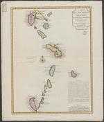 |
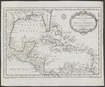
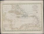
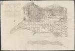
| Carte des Antilles Françoises et des isles voisines : dressée sur des memoires manuscrits de Mr. Petit Ingenieur du Roy, et sur quelques observations |
|
| Creator: | | Delisle, Guillaume, 1675-1726 |
| Publisher: | | Chez Jean Côvens et C. Mortier ( Amsterdam ) |
| Publication Date: | | 1717 |
| Type: | | Map |
| Format: | | 1 map : engraving, color ; 59,5 x 45 cm. |
| Source Institution: | | Universiteit Leiden |
| Subject Keyword: | |
Franse Antillen
Caribisch gebied
Kaarten (vorm)
|
| Spatial Coverage: | |
Franse Antillen
Caribisch gebied
|
| Genre: | | Kaarten (vorm) (gtt) |
| Language: | | French |
|
| Carte des Antilles Françoises et des isles voisines : dressée sur des memoires manuscrits de Mr. Petit Ingenieur du Roy, et sur quelques observations |
|
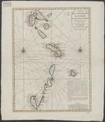 |
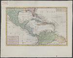
| Carte des Antilles Françoises et des isles voisines : dressée sur des memoires manuscrits de Mr. Petit Ingenieur du Roy, et sur quelques observations |
|
| Creator: | | Delisle, Guillaume, 1675-1726 |
| Publisher: | | Chez Jean Côvens et C. Mortier ( Amsterdam ) |
| Publication Date: | | 1717 |
| Type: | | Map |
| Format: | | 1 map : engraving, color ; 59,5 x 45 cm. |
| Source Institution: | | Universiteit Leiden |
| Subject Keyword: | |
Franse Antillen
Caribisch gebied
Kaarten (vorm)
|
| Spatial Coverage: | |
Franse Antillen
Caribisch gebied
|
| Genre: | | Kaarten (vorm) (gtt) |
| Language: | | French |
|
| Carte des Antilles Françoises et des isles voisines : dressée sur des memoires manuscrits de Mr. Petit Ingenieur du Roy, et sur quelques observations |
|
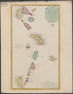 |
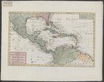
| Carte des Antilles Françoises et des isles voisines : dressée sur des memoires manuscrits de Mr. Petit Ingenieur du Roy, et sur quelques observations |
|
| Creator: | | Delisle, Guillaume, 1675-1726 |
| Publisher: | | Chez I'auteur sur le Quay de l'Horloge ( Paris ) |
| Publication Date: | | 1717 |
| Type: | | Map |
| Format: | | 1 map : engraving, color ; 64,5 x 37,5 cm. |
| Source Institution: | | Universiteit Leiden |
| Subject Keyword: | |
Franse Antillen
Caribisch gebied
Kaarten (vorm)
|
| Spatial Coverage: | |
Franse Antillen
Caribisch gebied
|
| Genre: | | Kaarten (vorm) (gtt) |
| Language: | | French |
|
| Carte des Antilles Françoises et des isles voisines : dressée sur des memoires manuscrits de Mr. Petit Ingenieur du Roy, et sur quelques observations |
|
|
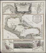 |
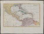
| Mappa geographica complectens I. Indiae Occidentalis, partem mediam circum Isthmum Panamensem, II. Ipsumque Isthmum, III. Ichnographiam praecipuorum locorum & portuum ad has terras pertinentium : desumta omnia ex Historia Insulae S. Dominici & pro praesenti statu belli, quod est 1740 inter Anglos & Hispanos exportum |
|
| Creator: | | Anville, Jean Baptiste Bourguignon d' |
| Publisher: | | Homannianes Heredes ( Nürnberg ) |
| Publication Date: | | 1740 |
| Type: | | Map |
| Format: | | 1 krt. : kopergrav., in kleur. ; 57 x 48 cm. |
| Source Institution: | | Universiteit Leiden |
| Subject Keyword: | |
Golf van Mexico
Kaarten (vorm)
|
| Spatial Coverage: | | Golf van Mexico |
| Genre: | | Kaarten (vorm) (gtt) |
| Language: | |
Latin
French
|
|
| Mappa geographica complectens I. Indiae Occidentalis, partem mediam circum Isthmum Panamensem, II. Ipsumque Isthmum, III. Ichnographiam praecipuorum locorum & portuum ad has terras pertinentium : desumta omnia ex Historia Insulae S. Dominici & pro praesenti statu belli, quod est 1740 inter Anglos & Hispanos exportum |
|
 |
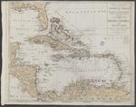
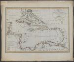
| Carte du Golphe du Méxique et des Isles de l'Amérique : pour servir à l'histoire générale des voyages |
|
| Creator: | | Bellin, Jacques Nicolas, 1703-1772 |
| Publication Date: | | 1754 |
| Type: | | Map |
| Format: | | 1 map : coppe rgravure ; 27,5×38 cm. |
| Source Institution: | | Universiteit Leiden |
| Subject Keyword: | |
Caribisch gebied
Golf van Mexico
Kaarten (vorm)
|
| Spatial Coverage: | |
Caribisch gebied
Golf van Mexico
|
| Genre: | | Kaarten (vorm) (gtt) |
| Language: | | French |
|
| Carte du Golphe du Méxique et des Isles de l'Amérique : pour servir à l'histoire générale des voyages |
|
 |
| Kaart van de onderkoningschappen van Mexico en Nieuw Granada in de Spaansche West-Indien |
|
| Creator: | | Tirion, Isaak, 1705-1765 |
| Publisher: | | Isaak Tirion ( Amsterdam ) |
| Publication Date: | | 1765 |
| Type: | | Map |
| Format: | | 1 map : print, copper engraving, coloured ; 29,5 x 47,3 cm. |
| Source Institution: | | Universiteit Leiden |
| Subject Keyword: | |
Caribisch gebied
Kaarten (vorm)
|
| Spatial Coverage: | | Caribisch gebied |
| Genre: | | Kaarten (vorm) (gtt) |
| Language: | | Dutch |
|
| Kaart van de onderkoningschappen van Mexico en Nieuw Granada in de Spaansche West-Indien |
|
|
 |
| Kaart van de onderkoningschappen van Mexico en Nieuw Granada in de Spaansche West-Indien |
|
| Creator: | | Tirion, Isaak, 1705-1765 |
| Publisher: | | Isaak Tirion ( Amsterdam ) |
| Publication Date: | | 1765 |
| Type: | | Map |
| Format: | | 1 map : print, copper engraving, coloured ; 29,5 x 47,3 cm. |
| Source Institution: | | Universiteit Leiden |
| Subject Keyword: | |
Caribisch gebied
Kaarten (vorm)
|
| Spatial Coverage: | | Caribisch gebied |
| Genre: | | Kaarten (vorm) (gtt) |
| Language: | | Dutch |
|
| Kaart van de onderkoningschappen van Mexico en Nieuw Granada in de Spaansche West-Indien |
|
 |
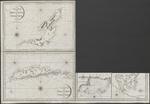
| Plano de la Ciudad de Kingston en la Jamaica : Segun el proyecto del Coronel Christian Lilly ... |
|
| Creator: | | Lopez, Don Juan |
| Publication Date: | | 1782 |
| Type: | | Map |
| Format: | | 4 maps in 1 sheet : engraving, color ; Sheet 39×40,5 cm. |
| Source Institution: | | Universiteit Leiden |
| Subject Keyword: | |
Jamaica
Caribisch gebied
Kaarten (vorm)
|
| Spatial Coverage: | |
Jamaica
Caribisch gebied
|
| Genre: | | Kaarten (vorm) (gtt) |
| Language: | | Spanish |
|
| Plano de la Ciudad de Kingston en la Jamaica : Segun el proyecto del Coronel Christian Lilly ... |
|
 |
| Kaart van de Golf van Mexico, de Eilanden en de Aangrenzende Landschappen |
|
| Creator: | | Kitchin, Thomas |
| Publisher: | | Bij de Wed. J. Dóll ( Amsterdam ) |
| Publication Date: | | 1787 |
| Type: | | Map |
| Format: | | 1 map : copper gravure, color ; 31x47,5 cm. |
| Source Institution: | | Universiteit Leiden |
| Subject Keyword: | |
Caribisch gebied
Kaarten (vorm)
|
| Spatial Coverage: | | Caribisch gebied |
| Genre: | | Kaarten (vorm) (gtt) |
| Language: | | Dutch |
|
| Kaart van de Golf van Mexico, de Eilanden en de Aangrenzende Landschappen |
|
 |
| Charte von West Indien nach der grossen Charte des B. Edwards, Esqr. und andern zuverlassigne Hulfsmitteln neu entworfen von F.L. Gussefeld |
|
| Creator: | | Güssefeld, Franz Ludwig, 1744-1807 |
| Publisher: | | im Verlag des Industrie Comptoirs ( Weimar ) |
| Publication Date: | | 1795 |
| Type: | | Map |
| Format: | | 1 map : copper gravure, color ; 43,5 x61,5 cm. |
| Source Institution: | | Universiteit Leiden |
| Subject Keyword: | |
Caribisch gebied
Kaarten (vorm)
|
| Spatial Coverage: | | Caribisch gebied |
| Genre: | | Kaarten (vorm) (gtt) |
| Language: | | German |
|
| Charte von West Indien nach der grossen Charte des B. Edwards, Esqr. und andern zuverlassigne Hulfsmitteln neu entworfen von F.L. Gussefeld |
|
|
 |
| Tabula Geographica Maximae Partis Americae Mediae sive Indiae Occidentalis : Karte des betraechtlichsten Theils von Mittel-America oder Westindien |
|
| Creator: | | Walch, Johann |
| Publisher: | | bey Johanes Walch ( Augsburg ) |
| Publication Date: | | 1798 |
| Type: | | Map |
| Format: | | 1 map : copper gravure, color ; 49x60 cm. |
| Source Institution: | | Universiteit Leiden |
| Subject Keyword: | |
Caribisch gebied
Kaarten (vorm)
|
| Spatial Coverage: | | Caribisch gebied |
| Genre: | | Kaarten (vorm) (gtt) |
| Language: | | German |
|
| Tabula Geographica Maximae Partis Americae Mediae sive Indiae Occidentalis : Karte des betraechtlichsten Theils von Mittel-America oder Westindien |
|
 |
| A new and accurate Mercators chart of the Bay of Honduras, Mosquito Shore and the British Yucatan, also the Bahama Islands : including Jamaica, Cuba, Hispaniola, part of East Florida &c |
|
| Creator: | | Steel, D |
| Publisher: | | D. Steel ( London ) |
| Publication Date: | | 1800 |
| Type: | | Map |
| Format: | | 1 map : copper gravure ; 107x120 cm. |
| Source Institution: | | Universiteit Leiden |
| Subject Keyword: | |
Caribisch gebied
Kaarten (vorm)
|
| Spatial Coverage: | | Caribisch gebied |
| Genre: | | Kaarten (vorm) (gtt) |
| Language: | | English |
|
| A new and accurate Mercators chart of the Bay of Honduras, Mosquito Shore and the British Yucatan, also the Bahama Islands : including Jamaica, Cuba, Hispaniola, part of East Florida &c |
|
 |
| Charte over den Danske Oe St. Jan i America Optaget i Aaret 1780, og ugdiveti Aaret 1800 |
|
| Creator: | | Oxholm, Peter Lotharius |
| Publisher: | | G.N. Angelo ( Kobenhavn ) |
| Publication Date: | | 1800 |
| Type: | | Map |
| Format: | | 1 map : engraving ; 59,5 x 100 cm. |
| Source Institution: | | Universiteit Leiden |
| Subject Keyword: | |
Caribisch gebied
Virgin Islands
Kaarten (vorm)
|
| Spatial Coverage: | |
Caribisch gebied
Virgin Islands
|
| Genre: | | Kaarten (vorm) (gtt) |
| Language: | | Danish |
|
| Charte over den Danske Oe St. Jan i America Optaget i Aaret 1780, og ugdiveti Aaret 1800 |
|
 |
| Charte over den Danske Oe St Croix i America |
|
| Creator: | | Oxholm, Peter Lotharius |
| Publisher: | | G.N. Angelo ( Kobenhavn ) |
| Publication Date: | | 1800 |
| Type: | | Map |
| Format: | | 1 map in 2 sheets : engraving ; 66 x 200 cm. |
| Source Institution: | | Universiteit Leiden |
| Subject Keyword: | |
Caribisch gebied
Virgin Islands
Kaarten (vorm)
|
| Spatial Coverage: | |
Caribisch gebied
Virgin Islands
|
| Genre: | | Kaarten (vorm) (gtt) |
| Language: | | Danish |
|
| Charte over den Danske Oe St Croix i America |
|
|
 |
| Charte von West Indien : nach Edwards, De la Rochette und den neuesten astronomischen Beobachtungen entworfen |
|
| Creator: | | Güssefeld, Franz Ludwig, 1744-1807 |
| Publisher: | | Geografisches Institut ( Weimar ) |
| Publication Date: | | 1804 |
| Type: | | Map |
| Format: | | 1 krt. : kopergravure. ; 43x60,5 cm, blad 68x57 cm. |
| Source Institution: | | Universiteit Leiden |
| Subject Keyword: | |
Caribisch gebied
Kaarten (vorm)
|
| Spatial Coverage: | | Caribisch gebied |
| Genre: | | Kaarten (vorm) (gtt) |
| Language: | | German |
|
| Charte von West Indien : nach Edwards, De la Rochette und den neuesten astronomischen Beobachtungen entworfen |
|
 |
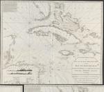
| The island of Becouya |
|
| Creator: | |
Heather, William, 1790-1812 fl
Stephenson, J, ca1780-ca1830 fl
|
| Publisher: | | Heather ( London ) |
| Publication Date: | | 1808 |
| Type: | | Map |
| Format: | | 5 maps in 1 sheet : copper gravure ; sheet 64x93 cm. |
| Source Institution: | | Universiteit Leiden |
| Subject Keyword: | |
Kleine Antillen
Caribisch gebied
Kaarten (vorm)
|
| Spatial Coverage: | |
Kleine Antillen
Caribisch gebied
|
| Genre: | | Kaarten (vorm) (gtt) |
| Language: | | English |
|
| The island of Becouya |
|
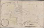 |
| A new and correct general chart of the West Indies including the Gulf of Mexico & Bay of Honduras &c. : collected from the Journals Surveys and Astronomical Observations, of the most celebrated navigators |
|
| Creator: | | Heather, William |
| Publisher: | | by William Heather ( London ) |
| Publication Date: | | 1811 |
| Type: | | Map |
| Format: | | 1 map : copper gravure ; 77x123,5 cm. |
| Source Institution: | | Universiteit Leiden |
| Subject Keyword: | |
Caribisch gebied
Kaarten (vorm)
|
| Spatial Coverage: | | Caribisch gebied |
| Genre: | | Kaarten (vorm) (gtt) |
| Language: | | English |
|
| A new and correct general chart of the West Indies including the Gulf of Mexico & Bay of Honduras &c. : collected from the Journals Surveys and Astronomical Observations, of the most celebrated navigators |
|
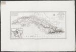 |
| Carte de l'ile de Cuba, redigée sur les observations astronomiques des navigeurs espagnols et sur celles de Mr. de Humboldt |
|
| Creator: | |
Humboldt, Alexander von, 1769-1859
Lapie, Pierre, 1779-1850
|
| Publication Date: | | 1820 |
| Type: | | Map |
| Format: | | 1 kaartblad : ; 31,5 x 64 cm. |
| Source Institution: | | Universiteit Leiden |
| Subject Keyword: | |
Caribisch gebied
Cuba
Kaarten (vorm)
|
| Spatial Coverage: | |
Caribisch gebied
Cuba
|
| Genre: | | Kaarten (vorm) (gtt) |
| Language: | | French |
|
| Carte de l'ile de Cuba, redigée sur les observations astronomiques des navigeurs espagnols et sur celles de Mr. de Humboldt |
|
|
