 |
| De Benedenwinden in vogelvlucht |
|
| Creator: | | Zonneveld, J.I.S |
| Publication Date: | | 1954 |
| Type: | | Book |
| Source Institution: | | Universiteit Leiden |
| Genre: | | non-fiction (marcgt) |
| Language: | | Dutch |
|
| De Benedenwinden in vogelvlucht |
|
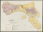 |
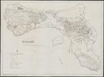
| Geological and land use map of Bonaire |
|
| Creator: | |
Westermann, J.H
Zonneveld, J.I.S
|
| Publisher: | | Royal tropical institute ( Amsterdam ) |
| Publication Date: | | 1956 |
| Type: | | Map |
| Format: | | 1 kaart. : in kleur. ; 63 x 85 cm. |
| Source Institution: | | Universiteit Leiden |
| Language: | | English |
|
| Geological and land use map of Bonaire |
|
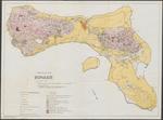 |
| Geological and land use map of Bonaire |
|
| Creator: | |
Westermann, J.H
Zonneveld, J.I.S
|
| Publisher: | | Royal tropical institute ( Amsterdam ) |
| Publication Date: | | 1956 |
| Type: | | Map |
| Format: | | 1 kaart. : in kleur. ; 63 x 85 cm. |
| Source Institution: | | Universiteit Leiden |
| Language: | | English |
|
| Geological and land use map of Bonaire |
|
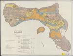 |
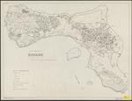
| Land capability and land use map of Bonaire |
|
| Creator: | |
Westermann, J.H
Zonneveld, J.I.S
|
| Publisher: | | Royal tropical institute ( Amsterdam ) |
| Publication Date: | | 1956 |
| Type: | | Map |
| Format: | | 1 kaart. : in kleur. ; 63 x 84 cm. |
| Source Institution: | | Universiteit Leiden |
| Language: | | English |
|
| Land capability and land use map of Bonaire |
|
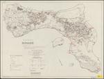 |
| Land use and sample location map of Bonaire |
|
| Creator: | |
Westermann, J.H
Zonneveld, J.I.S
|
| Publisher: | | Royal tropical institute ( Amsterdam ) |
| Publication Date: | | 1956 |
| Type: | | Map |
| Format: | | 1 kaart. : in kleur. ; 63 x 84 cm. |
| Source Institution: | | Universiteit Leiden |
| Language: | | English |
|
| Land use and sample location map of Bonaire |
|
 |
| Land use and sample location map of Bonaire |
|
| Creator: | |
Westermann, J.H
Zonneveld, J.I.S
|
| Publisher: | | Royal tropical institute ( Amsterdam ) |
| Publication Date: | | 1956 |
| Type: | | Map |
| Format: | | 1 kaart. : ; 63 x 84 cm. |
| Source Institution: | | Universiteit Leiden |
| Language: | | English |
|
| Land use and sample location map of Bonaire |
|
 |
| Land Use and Sample location map of Bonaire |
|
| Creator: | |
Westermann, J.H
Zonneveld, J.I.S, 1918-1995
|
| Publisher: | | Royal Tropical Institute ( Amsterdam ) |
| Publication Date: | | 1956 |
| Type: | | Map |
| Format: | | 1 map : black and white print ; 63 x 84 cm. |
| Source Institution: | | Universiteit Leiden |
| Subject Keyword: | | Bonaire |
| Spatial Coverage: | | Bonaire |
| Language: | | English |
|
| Land Use and Sample location map of Bonaire |
|
|
