|
|
| |
|
|
|
 |
| Conservation in the Caribbean : a review of literature on the destruction and conservation of renewable natural resources in the Caribbean area, with reference to the population problem |
|
| Creator: | | Westermann, J.H |
| Publisher: | | Foundation for Scientific Research in Surinam and The Netherlands Antilles = Natuurwetenschappelijke Studiekring voor Suriname en de Nederlandse Antillen ( Utrecht, Amsterdam ) |
| Publication Date: | | 1952 |
| Type: | | Book |
| Format: | | 121 p. : ill. ; 24 cm. |
| Source Institution: | | Universiteit Leiden |
| Subject Keyword: | |
Conservation of natural resources -- Caribbean Area
Renewable natural resources -- Caribbean Area
|
| Spatial Coverage: | | Caribbean Area |
| Genre: | | non-fiction (marcgt) |
| Language: | | English |
|
| Conservation in the Caribbean : a review of literature on the destruction and conservation of renewable natural resources in the Caribbean area, with reference to the population problem |
|
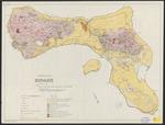 |
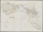
| Geological and land use map of Bonaire |
|
| Creator: | |
Westermann, J.H
Zonneveld, J.I.S
|
| Publisher: | | Royal tropical institute ( Amsterdam ) |
| Publication Date: | | 1956 |
| Type: | | Map |
| Format: | | 1 kaart. : in kleur. ; 63 x 85 cm. |
| Source Institution: | | Universiteit Leiden |
| Language: | | English |
|
| Geological and land use map of Bonaire |
|
 |
| Geological and land use map of Bonaire |
|
| Creator: | |
Westermann, J.H
Zonneveld, J.I.S
|
| Publisher: | | Royal tropical institute ( Amsterdam ) |
| Publication Date: | | 1956 |
| Type: | | Map |
| Format: | | 1 kaart. : in kleur. ; 63 x 85 cm. |
| Source Institution: | | Universiteit Leiden |
| Language: | | English |
|
| Geological and land use map of Bonaire |
|
 |
| The geology of Aruba |
|
| Creator: | | Westermann, J.H |
| Publisher: | | Oosthoek's Uitgeversmaatij. ( Utrecht ) |
| Publication Date: | | 1932 |
| Type: | | Book |
| Format: | | 129, III p., [3] bl. pl. : krt. ; 30 cm. |
| Source Institution: | | Universiteit Leiden |
| Subject Keyword: | | Geology -- Aruba |
| Spatial Coverage: | | Aruba |
| Genre: | |
theses (marcgt)
non-fiction (marcgt)
|
| Language: | | English |
|
| The geology of Aruba |
|
|
 |
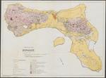
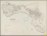
| Land capability and land use map of Bonaire |
|
| Creator: | |
Westermann, J.H
Zonneveld, J.I.S
|
| Publisher: | | Royal tropical institute ( Amsterdam ) |
| Publication Date: | | 1956 |
| Type: | | Map |
| Format: | | 1 kaart. : in kleur. ; 63 x 84 cm. |
| Source Institution: | | Universiteit Leiden |
| Language: | | English |
|
| Land capability and land use map of Bonaire |
|
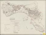 |
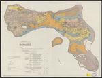
| Land use and sample location map of Bonaire |
|
| Creator: | |
Westermann, J.H
Zonneveld, J.I.S
|
| Publisher: | | Royal tropical institute ( Amsterdam ) |
| Publication Date: | | 1956 |
| Type: | | Map |
| Format: | | 1 kaart. : in kleur. ; 63 x 84 cm. |
| Source Institution: | | Universiteit Leiden |
| Language: | | English |
|
| Land use and sample location map of Bonaire |
|
 |
| Land use and sample location map of Bonaire |
|
| Creator: | |
Westermann, J.H
Zonneveld, J.I.S
|
| Publisher: | | Royal tropical institute ( Amsterdam ) |
| Publication Date: | | 1956 |
| Type: | | Map |
| Format: | | 1 kaart. : ; 63 x 84 cm. |
| Source Institution: | | Universiteit Leiden |
| Language: | | English |
|
| Land use and sample location map of Bonaire |
|
 |
| Land Use and Sample location map of Bonaire |
|
| Creator: | |
Westermann, J.H
Zonneveld, J.I.S, 1918-1995
|
| Publisher: | | Royal Tropical Institute ( Amsterdam ) |
| Publication Date: | | 1956 |
| Type: | | Map |
| Format: | | 1 map : black and white print ; 63 x 84 cm. |
| Source Institution: | | Universiteit Leiden |
| Subject Keyword: | | Bonaire |
| Spatial Coverage: | | Bonaire |
| Language: | | English |
|
| Land Use and Sample location map of Bonaire |
|
|
 |
| Richtlijnen voor de economische en sociale ontwikkeling der Bovenwindse eilanden |
|
| Creator: | |
Kruijer, G.J, 1919-1986
Veenenbos, Jacobus Simon
Westermann, J.H
Voorlichtingsinstituut voor het Welvaartsplan Nederlandse Antillen (Amsterdam)
|
| Publisher: | | Voorlichtingsinstituut voor het Welvaartsplan Nederlandse Antillen ( Amsterdam ) |
| Publication Date: | | 1953 |
| Type: | | Book |
| Format: | | v, 76, 7 p. : ; 25 cm. |
| Source Institution: | | Leiden University |
| Subject Keyword: | |
Sociaal-economische situatie
Nederlandse Antillen
|
| Spatial Coverage: | | Nederlandse Antillen |
| Genre: | | non-fiction (marcgt) |
| Language: | | Dutch |
|
| Richtlijnen voor de economische en sociale ontwikkeling der Bovenwindse eilanden |
|
|
|
|
|
